Technology now interprets the physical world in smarter digital ways. Machines analyze object spaces, movement patterns, and environmental context continuously. This capability allows software to understand how objects exist inside physical environments. Businesses use this intelligence to improve mapping, robotics, logistics, and augmented reality systems. Developers and researchers often ask a basic foundational question. What is spatial intelligence, and how does it work in modern technology platforms. Understanding spatial reasoning helps organizations build smarter digital systems and applications. It allows software to process location, orientation, movement, and physical relationships accurately.
Spatial reasoning has always existed within human cognitive abilities. Humans naturally visualize objects in three-dimensional environments and spaces. Technology now attempts to replicate that capability using artificial intelligence and sensors. Companies integrate sensors, cameras, machine learning, and spatial data analytics. Understanding what is the spatial intelligence helps organizations adopt these technologies strategically. Businesses use spatial analysis to design better products, services, and digital experiences.
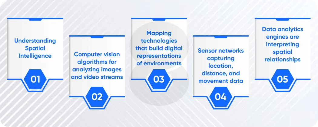
Understanding Spatial Intelligence
Many professionals ask a simple foundational question during research discussions. What is the spatial intelligence within technological and cognitive contexts. Spatial intelligence refers to the ability to understand relationships between objects and environments. It includes recognizing shapes, patterns, distances, and spatial orientation accurately.
Humans use spatial reasoning constantly during everyday activities. Driving, navigating cities, or assembling furniture requires spatial understanding. The brain visualizes objects’ movement and environmental relationships continuously.
Technology now attempts to simulate this capability through intelligent algorithms. Sensors, cameras, and mapping systems collect environmental information automatically. Artificial intelligence analyzes this information and builds spatial models of environments. Spatial intelligence systems usually combine several technical components.
- Computer vision algorithms for analyzing images and video streams
- Mapping technologies that build digital representations of environments
- Sensor networks capturing location, distance, and movement data
- Data analytics engines are interpreting spatial relationships
These technologies work together to produce spatial awareness within digital platforms.
Organizations now integrate spatial reasoning capabilities across many technology products. Navigation systems use spatial data to calculate efficient travel routes. Robotics platforms interpret physical environments to avoid obstacles during movement.
Understanding what is the spatial intelligence becomes important for developers and engineers. They must design systems capable of interpreting spatial data accurately.
Core Components of Spatial Intelligence Systems
Spatial intelligence systems rely on multiple technological layers working together. Each component captures interprets or processes spatial data from real environments.
The following table explains key elements within spatial intelligence architecture.
# |
Component |
Function |
| 1 | Sensors | Capture location motion and environmental data |
| 2 | Computer Vision | Analyze images objects and spatial relationships |
| 3 | Data Processing | Interpret spatial patterns and contextual signals |
| 4 | Applications | Deliver insights through software platforms |
Sensors represent the first layer of spatial intelligence systems. Devices such as cameras lidar scanners and GPS receivers capture environmental information. Computer vision algorithms analyze these signals to identify objects and shapes. Machine learning models detect patterns across images and spatial coordinates.
Data processing engines then interpret the collected information. They calculate distances object orientation and environmental relationships. Applications present these insights through dashboards interfaces and analytics tools. Developers build these applications through modern software development platforms. Spatial systems also integrate cloud infrastructure for processing large data volumes. Cloud services handle image analysis mapping algorithms and spatial analytics workloads.
Read More: 10 Best AI Development Companies In The US
Why Spatial Intelligence Matters Today
Organizations increasingly rely on spatial data to improve decision making. Businesses analyze geographic patterns movement trends and environmental conditions continuously. Companies often ask what is the spatial intelligence when evaluating modern digital technologies. The answer becomes clearer when examining real world business applications.
Spatial analysis improves logistics operations by optimizing delivery routes. Retail companies analyze store layouts and customer movement patterns. Urban planners evaluate traffic patterns and city infrastructure design.
Technology companies also build innovative consumer experiences using spatial technologies. Augmented reality applications overlay digital information on physical environments. Gaming platforms create immersive experiences through spatial environment modeling.
Several factors drive rapid adoption of spatial intelligence technologies.
- Increasing availability of sensors and connected devices
- Advances in artificial intelligence and machine learning models
- High demand for location-aware digital services
- Growth of cloud computing and large scale data analytics
Read More: What Is Agentic AI? Definitions And Real-World Examples
Examples of Spatial Intelligence in Technology
Spatial intelligence appears in many everyday digital systems and platforms today. These systems analyze environments and deliver useful insights to users. The following examples illustrate common implementations across industries.
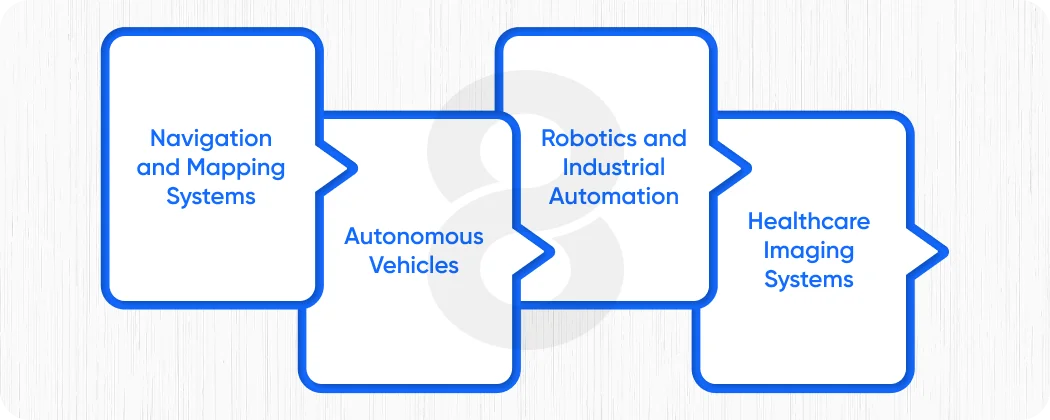
Navigation and Mapping Systems
Mapping platforms rely heavily on spatial data and geographic intelligence. Navigation software analyzes road networks distances and traffic conditions continuously.
Artificial intelligence models interpret location signals and route information. These systems recommend optimal paths for drivers and logistics companies. Developers build these systems through scalable software development frameworks.
Autonomous Vehicles
Self-driving vehicles represent advanced applications of spatial reasoning technologies. Vehicles interpret road conditions, obstacles and traffic behavior continuously.
Sensors, cameras, and lidar scanners generate massive spatial datasets. Artificial intelligence analyzes these signals through complex AI integration models.
Automation systems then guide vehicle movement safely through environments.
Robotics and Industrial Automation
Robots operating in warehouses require strong spatial awareness capabilities. They must identify object shelves, and pathways inside physical facilities.
Spatial intelligence allows robots to navigate environments without collisions. Industrial systems also coordinate logistics tasks through workflow automation engines.
Automation improves efficiency, accuracy, and operational safety across facilities.
Healthcare Imaging Systems
Medical imaging platforms also use spatial intelligence technologies. Doctors analyze 3D scans to diagnose medical conditions accurately.
Software interprets spatial relationships between organs, tissues, and structures. These systems support better diagnosis and treatment planning decisions.
Spatial Intelligence Applications in Business
Businesses increasingly rely on spatial insights to guide strategic decisions.
Location data, environmental context and spatial relationships influence many operations.
The following table highlights common business applications.
# |
Industry |
Spatial Intelligence Application |
| 1 | Logistics | Route optimization and delivery planning |
| 2 | Retail | Store layout analysis and customer movement tracking |
| 3 | Healthcare | Medical imaging analysis and surgical planning |
| 4 | Urban Planning | Infrastructure design and traffic pattern analysis |
Companies use spatial insights to improve efficiency, productivity, and customer experiences.
Spatial analysis also improves operational planning across logistics networks. Organizations analyze geographic demand patterns and transportation routes. Retail companies design store layouts based on spatial customer movement data. These insights help improve product placement and shopping experiences.
Healthcare providers analyze medical imaging data using spatial modeling tools. Doctors visualize internal structures and identify health conditions earlier. Spatial technologies also integrate with emerging digital ecosystems. Blockchain development sometimes secures spatial datasets across distributed systems. Secure spatial data improves transparency within supply chains and logistics networks.
Read More: 8 Industries Being Redefined by Computer Vision
How AI Enhances Spatial Intelligence
Artificial intelligence significantly improves spatial data interpretation capabilities. Machine learning models recognize patterns within images, maps, and environmental signals. Many engineers again ask the important question during system planning. What is the spatial intelligence when combined with advanced artificial intelligence systems?
AI expands spatial intelligence beyond simple geometric analysis. Algorithms now recognize complex relationships across multiple spatial dimensions. Computer vision systems identify objects, motion patterns, and environmental features. Deep learning models analyze video streams and 3D mapping data.
AI Integration with Spatial Data Systems
Developers implement these capabilities through advanced AI integration pipelines. These pipelines connect sensors cloud infrastructure and machine learning systems.
Automation platforms also rely on spatial insights to trigger actions. Operational systems interpret spatial signals and initiate workflow automation processes.
For example warehouse robots respond to spatial location data instantly. Automation engines direct robots to shelves based on spatial inventory maps.
Conversational Interfaces and Spatial Intelligence
Artificial intelligence also powers conversational spatial interfaces in some applications. Interactive assistants guide users through mapping, navigation or environment exploration.
These assistants often rely on chatbot development frameworks and natural language processing systems.
Practical Tips to Improve Spatial Intelligence
Spatial intelligence also exists as a cognitive skill within human learning. People can improve spatial awareness through practice and specific exercises.
Professionals working in design engineering or architecture often train these abilities.
The following techniques help improve spatial reasoning skills.
- Practice drawing 3D objects from different perspectives
- Solve puzzles involving shapes, patterns, and spatial relationships
- Use mapping and navigation exercises to improve orientation awareness
- Work with design tools requiring spatial visualization and modeling
Digital tools also help strengthen spatial reasoning skills. Many applications use interactive visual exercises and simulations. Mobile learning platforms built through mobile app development support spatial training exercises. Users interact with virtual environments and spatial challenges.
These tools help individuals understand object orientation and spatial relationships better. Gaming environments also strengthen spatial awareness abilities. Players navigate virtual spaces and solve environmental puzzles.
Educational platforms combine gamification with interactive spatial training activities.
Technical Challenges in Spatial Intelligence Development
Despite its benefits, spatial intelligence systems face technical challenges. Developers must handle complex environmental data from multiple sources.
Spatial data often includes images, maps, sensor signals, and geographic coordinates. Processing this information requires significant computing resources. Scalability becomes a major concern when analyzing large spatial datasets. Cloud infrastructure must support real time spatial analysis workloads. Security also becomes important when handling location based data. Sensitive geographic information must remain protected from unauthorized access.
Another challenge involves integrating spatial systems with existing technology platforms. Legacy infrastructure may not support advanced spatial analytics capabilities. Developers must design flexible systems capable of handling evolving spatial technologies. Automation pipelines help manage spatial data processing tasks efficiently. Automation engines coordinate analytics pipelines through workflow automation systems.
Read More: 25 Best AI Language Models – Choosing the Right Model for Your Project
Build Smarter Digital Systems with Spatial Intelligence Technologies

Companies or startups investing in spatial technologies unlock powerful new capabilities. Spatial insights improve logistics automation, mapping robotics, and interactive digital experiences.
Businesses that understand what is the spatial intelligence can design better technology products. They integrate artificial intelligence, cloud infrastructure, and modern development frameworks. Successful platforms combine software development expertise with advanced AI integration systems. Automation tools coordinate complex processes through intelligent workflow automation pipelines.
Companies also deliver spatial services through mobile applications built using mobile app development frameworks. Secure spatial datasets sometimes rely on blockchain development platforms for transparency. Conversational interfaces powered by chatbot development technologies improve user interaction with spatial platforms. Organizations combining these technologies will create powerful digital ecosystems and innovative solutions.
Read More: How Much Does Artificial Intelligence Cost
Conclusion
Spatial intelligence represents a powerful capability for understanding physical environments digitally. It allows machines and applications to interpret location, orientation, and spatial relationships.
Businesses use these insights across logistics, healthcare, robotics, mapping, and many industries. Artificial intelligence significantly expands the potential of spatial intelligence systems.
Developers integrate sensors, cloud infrastructure, and analytics platforms together. Automation systems process spatial data and trigger intelligent workflow automation responses.
Organizations building strong spatial capabilities gain long-term technological advantages. Spatial intelligence will continue shaping future innovation across digital ecosystems.